“Nature Trail Badge Challenge!” recommends six hiking trail routes for participants to visit and complete designated tasks. These routes are all at locations where The Green Earth’s “Repair Your Own Trails” volunteer team has carried out trail maintenance. We hope that through this activity, more nature lovers in Hong Kong can learn more about the stories behind hiking trails. Hence, spread the achievements of our efforts, and encourage everyone to take action to give back to nature and cherish these trails.
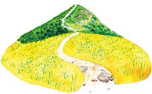
Ngong Ping Plateau is one of the few upland grasslands in Hong Kong. Standing on the green grassland, panoramic view of the Sai Kung Inland Sea and the Sai Kung Peninsula. Ma On Shan Country Trail is the most popular trail to reach the Ngong Ping Plateau. Connected with MacLehose Trail Section 4, Ma On Shan Country Trail attracts many visitors throughout the year.
Route:
Ma On Shan Tsuen Road➡ Ma On Shan Country Trail➡ Ngong Ping Plateau➡ Tai Shui Tseng, Sai Kung
The Yuen Tsuen Ancient Trail is a popular hiking spot in the central New Territories. Although it’s a bit long, the most challenging climb is only concentrated in the first kilometre, and the rest of the trail is fairly gentle, making it a medium-difficulty hike. It’s perfect for an autumn walk.
Routes:
Hong Kong Adventist Hospital – Tsuen Wan ➡ Yuen Tsuen Ancient Trail➡ Shek Lung Kung➡ Former Lin Fa Shan Public School ➡ Tin Fu Tsai➡ Tai Tong Barbecue Area➡ Tai Tong Shan Road, Yuen Long
Section 4 of the MacLehose Trail is 12.7km long, but we suggest that you only do half of it. If you turn right at the Ma On Shan Country Trail pavilion and walk towards Ma On Shan Village, you will have covered 7.6km. This route still reaches Ma On Au, which is 500m above sea level. Without a supply point you will find it very difficult. However, you will be rewarded with great views of the Inner Port Shelter along the MacLehose Trail. As you enjoy the views of distant hills and the sea, you will know that all your efforts have been worthwhile.
Route:
Shui Long Wo➡ MacLehose Trail Section 4➡ Wan Kuk Shan ➡Pavilion of the Ma On Shan Country Trail ➡Ma On Shan Village
According to Mr Kwok Chi-biu, a veteran researcher of ancient trails, the trail connecting Mau Ping and Pak Kong is part of the Sai Sha Ancient Trail. This trail was used by villagers to travel to and from Sai Kung and Siu Lek Yuen in the past. Nowadays, two well-known trails – Mau Ping Ancient Trail and Pak Kong Ancient Trail – still have their original stone steps and ridges, where the big rocks are covered in moss.As you walk along these trails, you will find yourself in a completely natural environment.
Routes:
Mui Tsz Lam road➡ Mui Tsz Lam➡ Mau Ping San Uk➡ Lau’s Ancestral Hal➡ Mau Ping Au➡ King of Gogovine
The trail starts at Tai Tong Shan Road, with Tai Lam plantations on both sides. As you walk through the forest, you will see how easily the land can be eroded. In recent years, the Department of Agriculture, Fisheries and Conservation has used different methods to repair the area.The ‘Reservoir Islands Viewpoint’ is a popular place to visit, as it offers a great view of Tai Lam Chung Reservoir.
Route:
Tai Tong Shan Road ➡ Tai Tong Barbecue Site ➡ MacLehose Trail Section 10 ➡ Reservoir Islands Viewpoint ➡ Wong Nai Tun Reservoir ➡ Yeung Ka Tsuen ➡ Shap Pat Heung Wong Nai Tun Tsuen Village Office
Sunset Peak is the third-tallest mountain in Hong Kong. It is 869 metres tall. If you want to hike to the top, be prepared for a difficult route with lots of climbing and descending. You can start your hike from Nam Shan along Lantau Trail Section 2, Pak Kung Au (the most popular starting point), or Wong Lung Hang Country Trail (a more difficult route).
Route:
Mui Wo ➡ Luk Tei Tong ➡ Nam Shan Old Village Path ➡ Lantau Trail Section 2 ➡ Sheung Tung Au ➡ Lantau Mountain Camp on Sunset Peak ➡ Pak Kung Au