“Nature Trail Badge Challenge!” recommends six hiking trail routes for participants to visit and complete designated tasks. These routes are all at locations where The Green Earth’s “Repair Your Own Trails” volunteer team has carried out trail maintenance. We hope that through this activity, more nature lovers in Hong Kong can learn more about the stories behind hiking trails. Hence, spread the achievements of our efforts, and encourage everyone to take action to give back to nature and cherish these trails.
Yuen Tsuen Ancient Trail
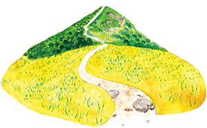
The Yuen Tsuen Ancient Trail is a popular hiking spot in the central New Territories. Although it’s a bit long, the most challenging climb is only concentrated in the first kilometre, and the rest of the trail is fairly gentle, making it a medium-difficulty hike. It’s perfect for an autumn walk. Historically, this trail was mainly used by villagers to travel between Tsuen Wan and Yuen Long. Some parts of the trail offer stunning views. When you reach the highest point, you can take in the scenery of Tsuen Wan, Tsing Yi Island and even see the Tsing Ma Bridge, Stonecutters BridgeNgong Shuen Chau Bridge and Ting Kau Bridge all at once.
The trail has been repaired over the years and most of it is now paved with cement or ornate stones. However, if you look carefully, you can still see remnants of the old trail. It’s a great place to enjoy a mix of old and new.
Hong Kong Adventist Hospital – Tsuen Wan ➡ Yuen Tsuen Ancient Trail➡ Shek Lung Kung➡ Former Lin Fa Shan Public School ➡ Tin Fu Tsai➡ Tai Tong Barbecue Area➡ Tai Tong Shan Road, Yuen Long
Distance:9.3 km
Time:5 hours
Difficulty:★★★☆☆
Supply Point:No supply point on the way
Safety reminders:
The mountain trail is long and there are many stretches where the phone signal is poor. It is advisable to be well prepared before setting off and to travel in groups.
Yuen Tsuen Ancient Trail overlaps with other hiking trails. Please note that the distance post number of the Yuen Tsuen Ancient Trail is C61xx.
There are many roads that split off from the Yuen Tsuen Ancient Trail. Please look for the road signs for the Yuen Tsuen Ancient Trail on the way.
Let’s Leave No Trace
You might see monkeys on the trail if it’s a quiet day. Please be kind to them and don’t give them food or plastic bags.
Appreciate the remnants of ancient trails and abandoned schools with your eyes and lens. Do not write on or take anything away.
任務一
沿途經過標距柱C6104,路標上指示,由該處前往田夫仔需時多久?
A. 1.5小時 B. 2小時 C. 3小時
(可以幻想一下昔日村民的行走時間呢!)
任務二
與以下其中一個指定地標拍下合照
1.石龍拱木牌
2.任何一段元荃古道砌石水泥山徑
Introduction Point I: Why there is an ‘‘Ancient Trail’’
In the early days of Hong Kong, the transport network was not well developed and residents had to walk to other villages or to and from various trading markets. As a result, there were many footpaths created by the villagers. These paths played an important role in cultural communication and commercial activities in the past.
Kwok Chi-biu, a senior researcher on ancient trails, says that the ancient trail we are talking about today was called a to-lo in the Qing Dynasty. Most to-los were the main roads between villages and markets. They were made of stone, which was strong and easy to travel on. People used them to visit relatives, go to weddings and festivals, and transport goods.
The name of an ancient trail is usually combined with the names of the places at both ends. For example, the Yuen Tsuen Ancient Trail was a route used to travel between Yuen Long and Tsuen Wan. This trail was created by former residents of Shap Pat Heung in Yuen Long, who crossed the hills through Tai Lam Country Park (which is now Tai Lam Country Park) to transport the crops to Tsuen Wan market, in exchange for their daily necessities. Nowadays, there is no need to travel through the wilderness to get between these two places, thanks to the highways and railways that have been built. The Yuen Tsuen Ancient Trail is a hiking trail that many people go to for fun.
Introduction Point II: " Ancient Trail " Improvement Project
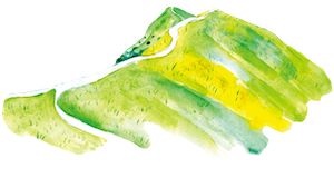
If you go hiking from Tsuen Wan, you will see that the old trail has been covered in cement to make it easier for villagers to get around. As you walk along, you will pass all the village houses and see that the trail has been changed from just a path to a stone road. This part of the trail was finished in May 2012 as part of a $3 million project to improve the Yuen Tsuen Ancient Trail. The Tsuen Wan District Office was in charge of this project. People have very different opinions about the new cement stone road.
Some people think the new road is easier to walk on and safer, but others think it doesn’t fit in with the natural surroundings, which makes the ancient path looks less ancient. It is also said that the road surface is too hard, which makes walking painful for the ankles and makes the road slippery when it rains. So many people prefer to walk on the nearby grass. There are many paths along the road. Some of these paths have been created by people using their mountain bikes the wrong way.
The design of the trail should consider people as well as nature, culture and history. The improvement project was completed over ten years ago. Looking back at this improved road today, would you like to keep the original look of the ancient trail, or make it “better” in the current way?
The stone road and the shortcut.
The tire marks created by mountain bikes
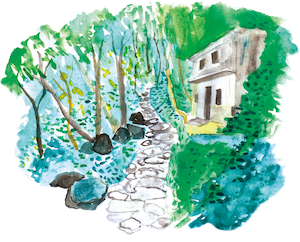
Introduction Point III: Ancient Trail Today and Past
Today, many ancient trails are still used, or have been maintained at some point. Although many sections of the Yuen Tsuen Ancient Trail have been replaced by roads made of cement, you can still spot traces of the ancient trails along the way.
The area covered in cement doesn’t let rainwater soak into the ground, so the soil next to the cement is washed away by rain. After many years of this, the soil is washed away, and on the edge of the cement on the trail, you can see the old stones of the ancient trail. These were covered with cement during the project to improve the trail. In the past, local villagers built the ancient trail with stones from the nearby hills. The stones came in different sizes and some were mossy. By looking at these old stones, you can see what the ancient trail used to look like.
If you go further towards Yuen Long, you will see more trails that have recently been fixed up with logs. The trails are in a remote area, so it is difficult to get to them by car. It is thought that the logs were left there after trees fell down.
If you are someone who designs trails and you want to rebuild this part of the old trail, how would you do it?
The soil below the cement was washed away, exposing the rocks of the ancient road. (Near distance post C6101-6102)
The trail under the Ancient Trail (At distance post C6104-6105)
Hand-made wood steps (At distance post C6113-6114)
Introduction Point IV: Mountain Slide (Lin Fa Shan Public School)
(There is a path split into two parts on the left of the distance marker C6104. After walking for about three minutes, you will see the white slide of the former Lin Fa Shan Public School, which is located behind the slide.)
The Lin Fa Shan Public School was built in the 1950s to give children from nearby villages a place to study. As new towns like Tuen Mun and Tsuen Wan were built, more and more people moved from the countryside to the urban areas. Rural schools, which were far away and had few facilities, were slowly closed. The Lin Fa Shan Public School closed in the 1980s.
The slide outside the school is the most well-preserved one. Since similar slides are almost extinct in Hong Kong, it has become a popular place for nostalgic photography.
The Education Bureau has not given a strict definition of a rural school, but most rural schools are located in remote suburban areas and set up by villagers for the children living nearby. Most of the rural schools were built in the early 1950s, before primary education became more common, and many village children were out of school due to the difficult travel conditions in rural areas of New Territories. The rural schools gave children in these villages access to basic education.
The school buildings are simple. Many schools in the countryside have only a few classrooms. In the early years, some of these schools had to use a teaching method where two or more classes of students would study in the same classroom.
Today, you can still see the ruins of the school buildings in the mountain. You can still see the classrooms, library, toilets and other facilities. The roof of the building has collapsed because it has been left for a long time. Large trees have grown up through the abandoned school. Please do not enter for your own safety.
(When you’ve finished your visit, you can go back to the Yuen Tsuen Ancient Trail to carry on your trip.)
Introduction point V: Complete the "Yuen Tsuen Ancient Trail"
When you reach the intersection marked “Towards Tsing Fai Tong” (near post C6112), you’ll know you’ve passed the halfway point on the Yuen Tsuen Ancient Trail!
In the past, people had really strong legs. It is said that they could travel to and from Yuen Long and Tsuen Wan in one day while carrying food and other things they needed.
Option one
Continue along the Yuen Tsuen Ancient Trail. From here, the trail goes on for another 8 km, and it will take about 3 hours to reach Tai Tong. The rest of the Yuen Tsuen Ancient Trail is more circuitous, and is made up of natural mud paths. On these paths, you can imagine what it was like for the villagers to travel to Yuen Long on foot in the past.
If you want to complete the Yuen Tsuen Ancient Trail, check out the maps on the websites below.
If you want to get back to the city for afternoon tea quickly, follow the trail to Tsing Fai Tong and walk to Sham Tseng. It takes about 1 hour (2.5 km). You can get a bus there too.
Follow the Yuen Tsuen Ancient Trail and connect to the MacLehose Trail Section 10